


The 3D visualisation of the Empire Exhibition was created by a team of experienced 3D modellers working at the Digital Design Studio. The modellers worked from dozens of small-scale drawings, hundreds of photographs and many maps to recreate the 3D virtual Empire Exhibition.
Each model was reviewed by a panel of ‘experts’ (see the Advisory Panel section) to ensure that models were as accurate as possible. The work took a team of, at its largest, five modellers about six months to complete.
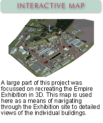
Once the 3D models had been completed and placed within the model of the park, a series of animations were set up. Some of these animations, together with the individual 3D building models, can be seen in this section under the Interactive Map.